
Carson National Forest, New Mexico
Do you manage this campground? Claim this page
At a glance: No electric hookups, drinking water or flush toilets. Listed for rigs up to 30 ft. Not listed: showers.
Get updates when fees or status change
Amenities
“Not listed” means the official sources don’t say - it does not mean “no”.
- Electric hookups No
- Drinking water No
- Flush toilets No
- Showers Not listed
- Dump station Not listed
- Water hookups at sites Not listed
- Sewer hookups Not listed
- Tent sites Not listed
- RV / trailer sites Not listed
- Reservable online Yes
Sites, fees and season
- Campsites
- 1
- Longest RV / trailer listed
- Up to 30 ft at selected sites (not every site; check access and your site)
- Elevation
- 8,301 ft
- Phone
- (575) 587-2255 (campground or managing office)
Fees are not listed in the official data. Check the official site before you go.
The listed length is the longest site; not every site fits that size. Confirm your site on the official reservation page.
From the official listing
The Amole Group Shelter is located immediately adjacent to the popular wooded Amole Canyon Day Use Area at 8,400 feet in elevation. The group shelter accommodates up to 100 people with plenty of solitude since this is the only group facility in this location.
Recreation
There are approximately 11 miles of non-motorized trails located in the Amole Canyon Day Use Area. Here, visitors can enjoy sections of the nearby South Loop Trail, with views of the Rio Pueblo Valley, and nearby Bear Mountain and Penasco Mountain. Along the Upper Cutoff Trail, views of Picuris Mountain are readily available. The trails are popular for hiking, mountain biking, snowshoeing and cross-country skiing and are rated easy to more difficult. The Amole Canyon Trailhead also provides access to the Forest's Motorized Trail System via Trail 182, the Tio Maes Trail.
Facilities
This location provides gated access, twin barbecue grills, picnic tables and a group-sized fire ring. In addition, accessible twin vault toilets with a paved path to the shelter are provided. There is no water at this facility and no trash service. Please bring all the water you will need for your stay and pack out your trash.
Natural Features
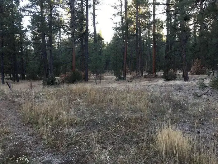
The group camping area has been constructed within a stand of tall ponderosa pine trees. The shelter has been constructed on a small hill overlooking a pristine meadow.
Climate by month
Average daily high and low and monthly precipitation, 1991-2020 normals from the NOAA station Gascon - 22.3 mi away, station at 8,250 ft - 51 ft lower than the campground (8,301 ft). Long-term averages, not a forecast; the open season is listed separately above.
| Month | High °F | Low °F | Precip. in |
|---|---|---|---|
| Jan | 44 | 18 | 0.96 |
| Feb | 45 | 20 | 1.46 |
| Mar | 51 | 24 | 1.92 |
| Apr | 57 | 29 | 1.91 |
| May | 65 | 36 | 1.88 |
| Jun | 75 | 43 | 1.79 |
| Jul | 76 | 47 | 4.68 |
| Aug | 74 | 46 | 3.87 |
| Sep | 69 | 41 | 2.26 |
| Oct | 61 | 32 | 1.63 |
| Nov | 52 | 24 | 1.30 |
| Dec | 44 | 18 | 1.28 |
Highlight months with an average high between and °F:
Location and nearby campgrounds
Location on the map · Driving directions · 36.18795, -105.60734 (the official listing point; check the access road for large rigs)
- Jacks Creek Group Area 24.1 mi straight-line
- Black Canyon Campground (Santa Fe National Forest, NM) 27.1 mi straight-line
- Holy Ghost Group Area 28.9 mi straight-line
- Field Tract Campground 35.0 mi straight-line
- Aldo Leopold House 37.9 mi straight-line
Photos from visitors
No visitor photos yet. Photos of the sites, restrooms and the road in help the next camper decide.
Visitor reviews
No reviews yet. Have you stayed here? Your experience helps the next camper.
Log in to write a reviewCreate a free account
Reviews are the personal experience of registered visitors. They do not change the official facts above; a reported problem (for example "the water was off") is checked against the official sources.
Estimate your trip cost
Sources
| Fact | Source | Fetched from the source |
|---|---|---|
| Campsites | Recreation.gov (RIDB) | Oct 25, 2026 source updated May 13, 2026 |
| Reservable online | Recreation.gov (RIDB) | Oct 25, 2026 source updated May 13, 2026 |
| Electric hookups | Recreation.gov (RIDB) | Oct 25, 2026 source updated May 13, 2026 |
| Drinking water | Recreation.gov (RIDB) | Oct 25, 2026 source updated May 13, 2026 |
| Flush toilets | Recreation.gov (RIDB) | Oct 25, 2026 source updated May 13, 2026 |
| Longest RV / trailer listed | Recreation.gov (RIDB) | Oct 25, 2026 source updated May 13, 2026 |
| Elevation | USGS elevation (EPQS) | Oct 25, 2026 |
| Official page | Recreation.gov (RIDB) | Oct 25, 2026 source updated May 13, 2026 |
| Official reservations | Recreation.gov (RIDB) | Oct 25, 2026 source updated May 13, 2026 |
| Phone | Recreation.gov (RIDB) | Oct 25, 2026 source updated May 13, 2026 |
Last successful data update for this page: Oct 25, 2026. That is when we last read the official sources - not a personal visit, and not the date the source itself changed (shown per fact above). Found something wrong? Report an error.